")
")
Identification of the Nominated Property
1.Country Kingdom of Thailand
1.State, Province or Region Nahon Si Thammarat Province, Southern Region of Thailand
1.c Name of the Nominated Property Wat Phra Mahathat Woramahawihan, Nakhon Si Thammarat
1.d Geographical coordinates to the nearest second
The nominated property is a single nomination. The geographical coordinates of the property central point to the nearest second are 8° 24’ 41.31” North and 99° 57’ 58.38” East, and the determinate area lies between 8° 24ʼ 48.47ˮ and 8° 24ʼ 34.50ˮ North and 99° 57ʼ 59.08ˮ and 99° 57ʼ 57.22ˮ East. The details as below.
Table 1-1 Geographical coordinates and sizes of the nominated property and buffer zone
|
Id No. |
Name of the component part |
Region (s) / District (s) |
Coordinates of the central point |
Area of nominated component part (ha) |
Area of the Buffer Zone (ha) |
Map No. |
|
001 |
Wat Phra Mahathat Woramahawihan |
Mueang Nakhon Si Thammarat district |
Latitude: 8° 24’ 41.31” N Longitude: 99° 57’ 58.38” E
|
5.356 |
113.136 |
1-2 |
|
Total area (in hectares) |
5.356 ha |
113.136 ha |
|
|||
- Nominated Property
Wat Phra Mahathat Woramahawihan, Nakhon Si Thammarat, the nominate property, is a Buddhist monastery that locates at 435 Ratchadamnoen Road, Nai Mueang Sub-District, Mueang Nakhon Si Thammarat District, Nakhon Si Thammarat Province, Southern (Peninsular) Region of Thailand, Southeast Asia. Geographically, it locates on the ancient eastern beach ridge, about 2-5 meters in height above the lower surrounding areas, and 1-5 kilometers in width. This ancient beach ridge of Nakhon Si Thammarat province runs in the north-south direction, parallel to the shoreline of the Gulf of Siam (Thailand). It was formed during marine transgressions around 6,000-8,000 years ago. Boundary of Wat Phra Mahathat approximately spans 130 meters in width and 400 meters in length, covering a total area of 5.356 hectares which legally listed as an Ancient Monument according to Royal Gazette, Volume 53, Page 1530, on the 27th September 1936 and announced boundary of the Ancient Monument on Royal Gazette, Volume 141, Special Issue 130 Ng, Page 7, on the 9th May 2024. Nowadays, boundary of the nominated property is surrounded by roads and urban communities, in which the northside is adjacent to Wat Phra Mahathat School, the eastside abuts onto Ratchadamnien Road and Wat Na Phra Borommathat, the southside adjoins Phra Lan Road and Wat Na Phra Lan, and the westside is bordered by Phra Borommathat Road and Wat Phra Nakhon.
- Buffer Zone
The nominated property is located within the central area of Nakhon Si Thammarat City and surrounded by governmental offices, religious places, schools, touristic facilities and urban communities. This area also overlays with the rectangular-shaped ancient town of Nakhon Si Thammarat in Ayutthaya period that its boundary is bordered by town walls and moats. Thus, buffer zone of this nominated property is determinate according to the boundary of Nakhon Si Thammarat ancient town, estimate area as 118.492 hectares (excludes area of the nominated property) which has been covered by the legal announced boundary of Nakhon Si Thammarat Old Town that defined by Announcement of Committee for Conservation and Development of Rattanakosin City and Old Towns and approved by the Cabinet in 2010 follows Regulations of the Office of the Prime Minister.
1.Maps and Plans, Showing the Boundaries of the Nominated Property and Buffer Zone
Table 1-2 List of maps of the nominated property and buffer zone
|
No. |
Name |
Scale - original maps |
Date |
Map No. |
|
001 |
Map of Thailand indicating Nakhon Si Thammarat province in which the nominated property is located |
1:5,000,000 |
Sep. 2024 |
1-1 |
|
002 |
Topographic map showing locations of Wat Phra Mahathat Woramahawihan, the nominated property, and buffer zone |
1:8,000 |
Sep. 2024 |
1-2 |
|
003 |
Orthophoto map showing locations of Wat Phra Mahathat Woramahawihan, the nominated property, and buffer zone |
1:8,000 |
Sep. 2024 |
1-3 |
|
004 |
Topographic map showing Wat Phra Mahathat Woramahawihan, the nominated property |
1:2,000 |
Sep. 2024 |
1-4 |
|
005 |
Orthophoto map showing Wat Phra Mahathat Woramahawihan, the nominated property |
1:2,000 |
Sep. 2024 |
1-5 |
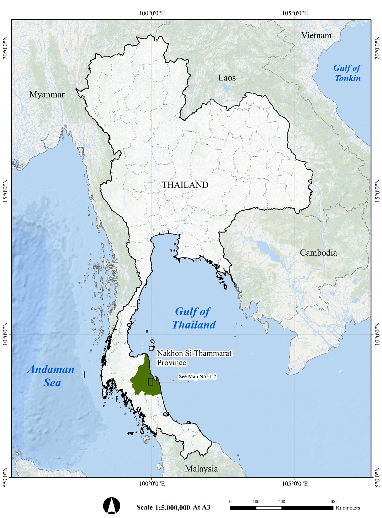
Map 1-1 Map of Thailand indicating Nakhon Si Thammarat province in which the nominated property is located
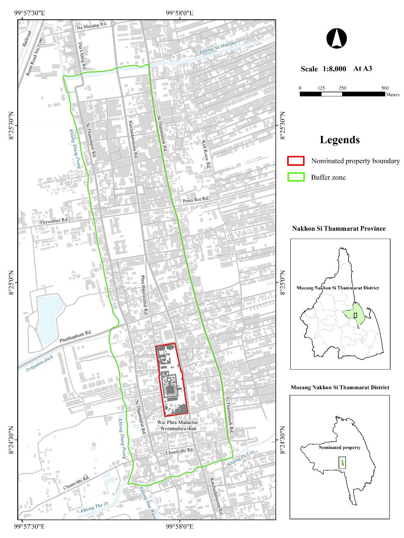
Map 1-2 Topographic map showing locations of Wat Phra Mahathat Woramahawihan, the nominated property, and buffer zone
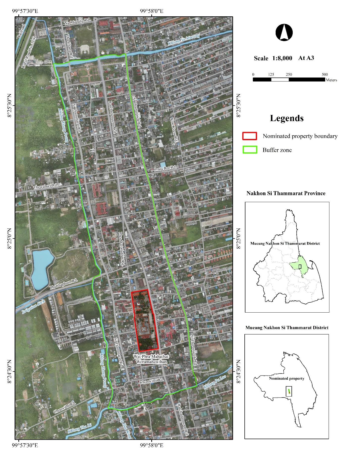
Map 1-3 Orthophoto map showing locations of Wat Phra Mahathat Woramahawihan, the nominated property, and buffer zone
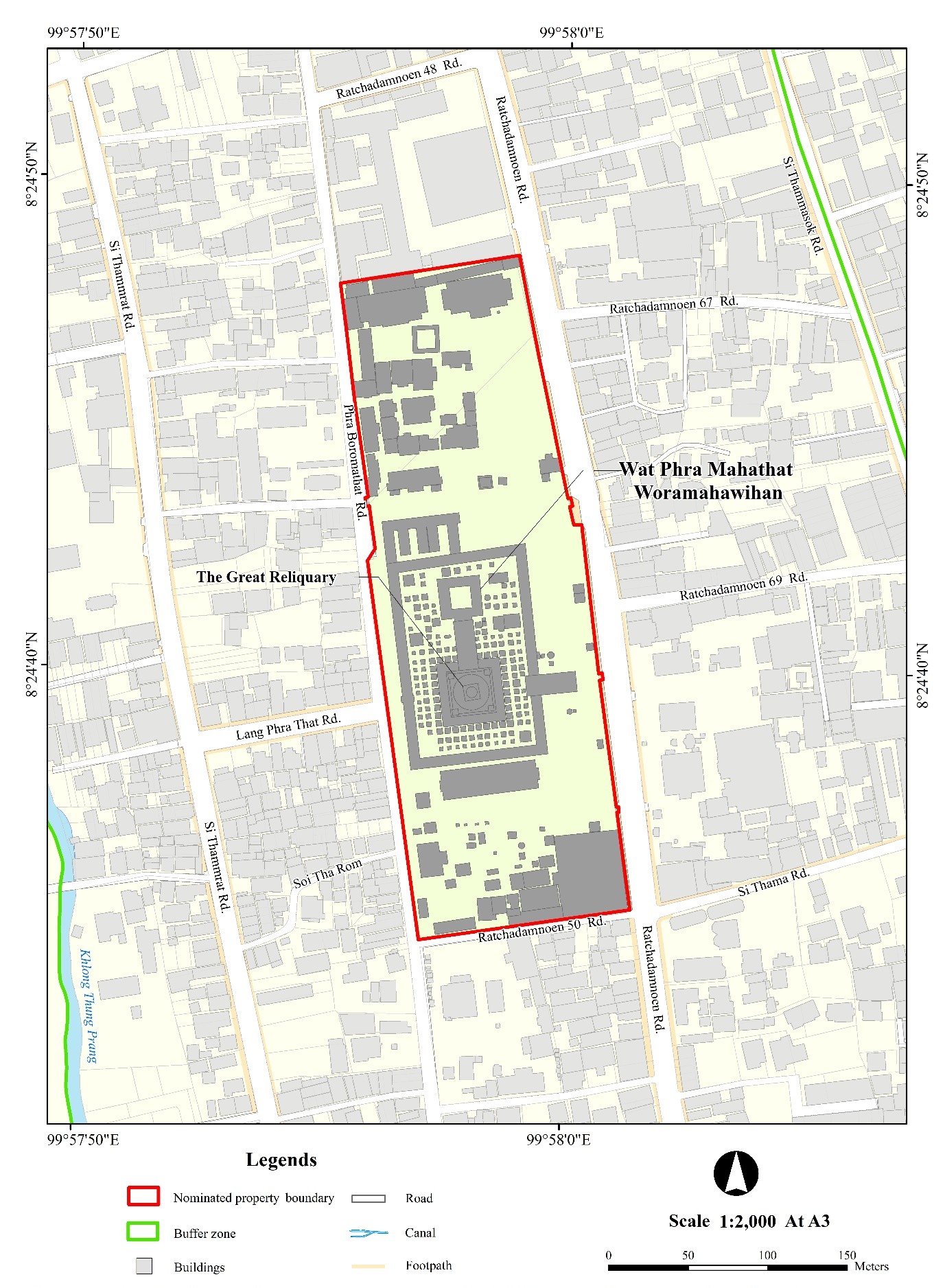
Map 1-4 Topographic map showing Wat Phra Mahathat Woramahawihan, the nominated property
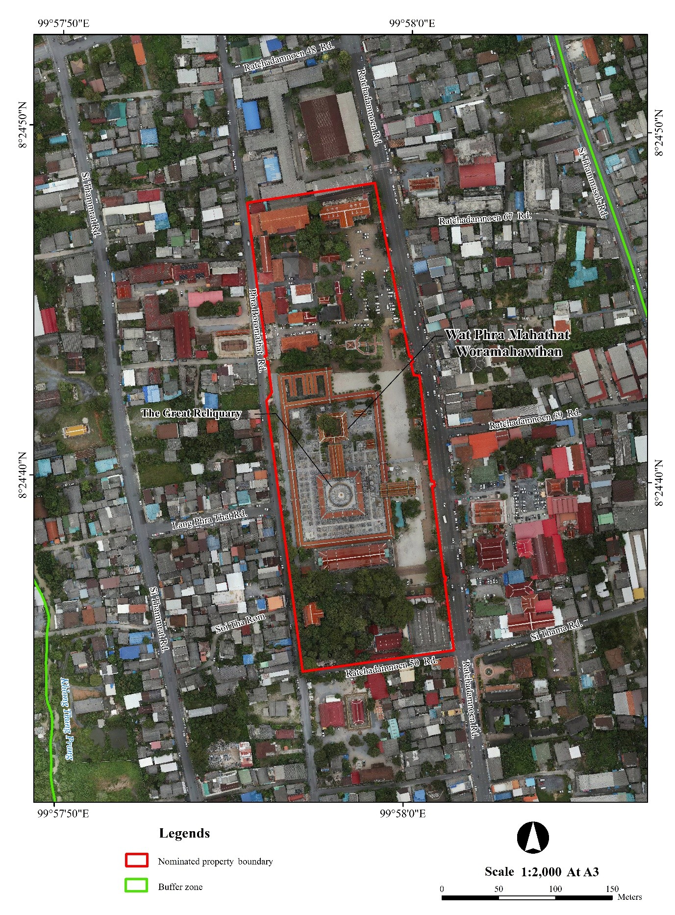
Map 1-5 Orthophoto map showing Wat Phra Mahathat Woramahawihan, the nominated property
1.Area of Nominated Property (ha.) and Proposed Buffer Zone (ha.)
Area of Nominated property: 5.356 ha
Buffer zone: 113.136 ha
Total 118.492 ha